
Things To Do
List of Things to Do in the Taos Canyon Area
Golf
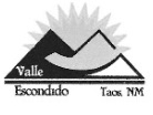
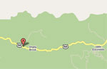
The nine-hole Valle Escondido course is located between Angel Fire and Taos on NM 64.
Click link to learn more—> Valle Escondido Golf Course Information
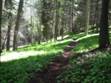
Trails in Taos Canyon
- The hikes on the south side of US Highway 64 in Taos Canyon are for pedestrians, bicycles, or horses only. There are no motorized vehicles allowed. This is according to Carson National Forest Travel Management Rule (36 CFR 212.55).
- The web address for Carson National Forest is: https://www.fs/usda.gov/carson ;
- The hiking trails web address is: https://www.fs.usda.gov/carson/recreation/hiking
New Mexico requires anyone under 18 to obtain a safety permit prior to operating an Off-Highway Vehicle on public lands. Information about motorcycle/ATV trails. Off-Highway Vehicles Hotline 1-800-366-4868.
Devisadero Trail (Loop Trail 108):

As
you enter the canyon from Taos there will be a parking lot on the south side of
Hwy 64. This parking lot is for Devisadero and South Boundary
Trails. Cross the highway to the north side to start the Devisadero
hike. The trail goes up to Devisadero Peak. The elevation
gain is 1125 ft. At the peak you have a choice to continue on a loop back
to the trail head at the highway (loop distance is about 5 miles).
As the loop trail drops off the peak to the east, you also have a choice to
intersect with the North Boundary Trail.
The
North Boundary Trail (495) is not totally marked on the local topographic maps
but the trail can be found on the ground.
See
Taos, NM 7.5 minutes topographic quadrangle for details. Trail details on
the map may not be precise.
North Boundary Trail (Trail 495)
The Carson National Forest Trail website identifies the North Boundary Trail as trail 495. When you access the North Boundary trail east of Devisadero Peak, the Taos quad identifies the trail as Trail 162. Trail 162 turns into a Y above Cordato Canyon. The south part of the Y is 162 and drops down to the gravel pit at the base of Cordato Canyon on US Highway 64.
The north part of the Y becomes Trail 717. The trail can be found on the ground as it migrates east onto the Pueblo Peak quad. This area is north of the Capulin Canyon access. Trail 717 eventually turns into a Y north of the Capulin Canyon access. The south part of this Y is Trail 717 and drops down to Capulin Canyon Road. The north part of this Y becomes Trail 494. Trail 494 migrates east in the Capulin Canyon area according to the Pueblo Peak quad. Eventually on this same quad as the trail migrates east it changes to 10A or 10A2 in the area of Casita de Piedra Canyon. Finally, on this same quad in the area of Baca Canyon the trail becomes 706A migrating east.
As you follow the trail onto the Palo Flechado Pass quad it continues as 706A and turns into 706 where the trail goes down La Junta Canyon to US Highway 64. Where La Junta Canyon intersects the highway there is a corral and a small parking area. This parking area is about one mile south of the La Jara Canyon horseshoe curve.
The North Boundary Trail is not totally marked on the local topographic maps but the trail can be found on the ground.
See Taos, NM 7.5 minute; Pueblo Peak, NM 7.5 minute; Palo Flechado Pass, NM 7.5 minute topographic quadrangles for details. Trail details on the maps may not be precise.
South Boundary Trail (Trail 164):

Park
in the same parking lot as Devisadero and cross the foot bridge to the south to
start your hike up to the South Boundary Trail. It is initially a steep
climb that ascends to the ridge along the Fernando Mtns. Follow the ridge
to the east all the way to Don Fernando Peak. The South Boundary Trail
eventually comes out at Angel Fire. From the parking lot to Don Fernando
Peak is about 13 miles. Stay on the main trail to get there. There
are many logging road spurs not shown on the map that take off from this trail.
Generally, Trail 164 stays high on the ridge. All the old logging
roads make a maze and will get you lost unless you know where to go.
The South Boundary Trail is not totally marked on the local topographic map, but the trail can be found on the ground. See Ranchos de Taos 7.5 minutes, Shady Brook, NM 7.5 minute, and Taos, NM 7.5 minutes topographic quadrangles for details. Trail details on the map may not be precise.
Ice Caves (Trail 109):

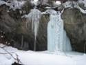
In
the wintertime there is a place called the Ice Caves where freezing water forms
a column of ice from a large ledge of Pennsylvanian Flechado Formation (approx.
310 m.y. geologic age) to the ground. The eroded rock under the
ledge and behind the column is about 15-20 feet tall. The dripping water
continues to drip inside the ice column. During the summer there is
constant dripping of water off the ledge.
At
approximately mile marker 261.5 along Highway 64 there is a parking area (not
too big) on the north side of the highway. Since the campgrounds are
closed in the winter you have to park here. Walk across the
highway. Follow the tracks in the snow to the west (in the winter the
snow is usually deep so snowshoes or crosscountry skis are recommended).
The trail eventually crosses the creek and you hike on the south side of the
creek. You will end up in Capulin Campground. Keep
following the tracks west and they will turn to the south into the
drainage. Follow them to the end where you will find the ice column with
trickling water inside it. Distance from where you park is about a mile.
See
Shady Brook, NM 7.5 minutes topographic quadrangle for details. Trail
details on the map may not be precise.
Mondragon Forest Road (Trail 660):


At
mile marker 264 along Highway 64 there is a semi-circle area on the north that
you can park to start your hike. Cross the road to the south and cross
the stream (usually 2 logs to cross on but in 2010 they were washed away).
Start your hike here. There are NO motorized
vehicles allowed in this area of Carson National Forest. This
is a great trail for hiking, bicycles, snowshoeing, cross country skiing and
horses.
At
about a half mile there is a Y in the road. Stay to the right for
Mondragon Forest Road. At about another half mile stay left on the main
road and don’t take the right spur. Eventually Mondragon Trail
takes a sharp right curve (this is about a 1¾ mile up from the stream – highway
crossing) across a usually dry drainage (Mondragon Drainage) then climbs a
small incline. At the top of this incline the road takes off to the right
(west) and left (south). There is a brown forest service no motor
vehicles sign on a tree at this Y.
By turning right (west) at this Y and hiking about 5 miles this west road (West Mondragon Forest Road-Trail 660) will take you on up to the South Boundary Trail (Trail 164), if you don’t take any wrong spurs. Once on the South Boundary Trail you can hike east to Don Fernando Peak (about 4 miles) or loop back west to the South Boundary trail head at the mouth of Taos Canyon (about 4 miles).
By
turning left (south) at this Y and going up the hill from the no motor vehicle
sign on the tree, you can take the “second” spur to the right which will also
go up to the South Boundary Trail. This spur has deep ruts from vehicles
and is steep for a short distance. As you start this “second” spur, stay
on the main road and it will switch back several times, climbing to the south
and ending up on South Boundary Trail. You come out on top about a mile
and a half west of Don Fernando Peak. This route from the stream at the
highway up to the South Boundary Trail and then to Don Fernando Peak will be
approximately 7 miles.
The
Mondragon Forest Road (Trail 660) is not totally marked on the local
topographic maps but the trail/road can be found on the ground.
There are also many logging road spurs not shown on the map that can create
confusion with following the Trail 660.
See Ranchos de Taos 7.5 minute and Shady Brook, NM 7.5 minutes topographic quadrangles for details. Trail details on the map may not be precise.
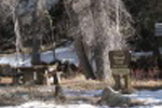
Campgrounds in Taos Canyon (closed during the winter)
Fees $$ for campground use are posted at each campground and will be picked up each day by the Carson camp host.
To see those fees on your phone or computer enter "Carson National Forest camping" in your search browser.
La Sombra
Elevation: 7800 ft
Ammenities: Fire pits, water, restrooms (User MUST pack out ALL trash!)
Fee: $ 1st vehicle, 2nd vehicle per night
Senior/Access Pass Discount $
Day use/picnic $
Capulin Campground
Elevation: 7797 ft
Ammenities: Fire pits, water, restrooms (User MUST pack out ALL trash!)
Fee: $ 1st vehicle and 2nd vehicle per night
Senior/Access Pass discount $
Day use/ picnic $
Las Petacas
Elevation: 7400 ft
Ammenities: Fire pits, restrooms (User MUST pack out all trash!)
Fee: $ 1st vehicle and 2nd vehicle, per night
Senior/Access Pass Discount $
Day Use/Picnic $